
Proposed Project Timeline
Public Scoping: December 4, 2023 – December 17, 2023 (COMPLETE)
Draft EA for Public Comment (30 day period): May 2 – May 31, 2024 (COMPLETE)
Final EA and Decision: July 24, 2024 (COMPLETE)
Proposed Implementation: July 2024 – Fall 2025
Project Summary
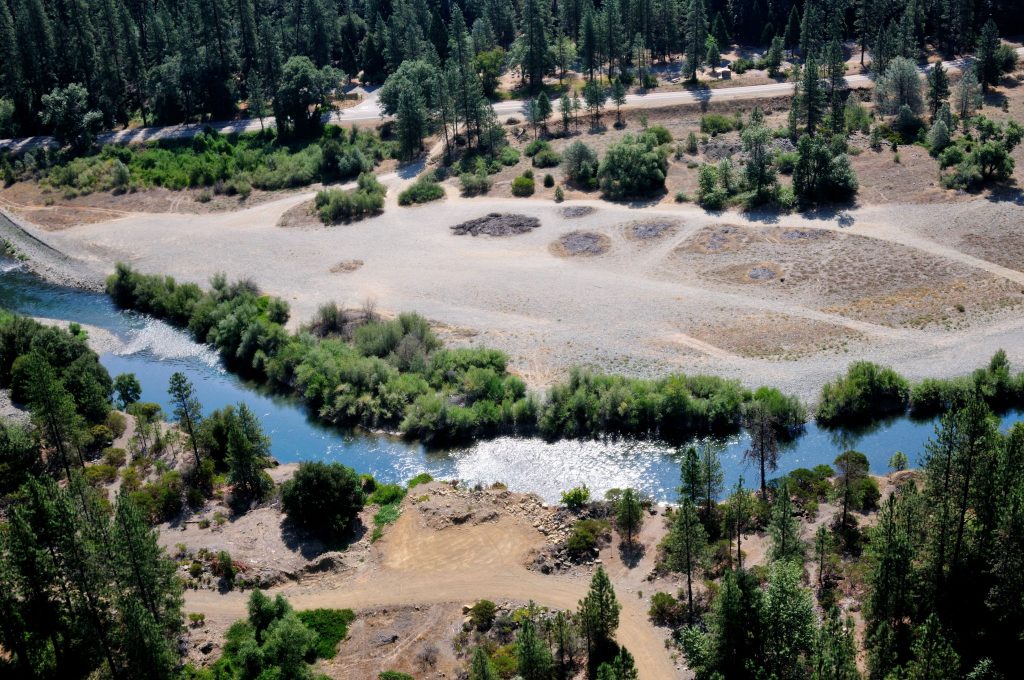
Situated one river mile downstream from the Dutch Creek Bridge in Junction City, CA, between river miles 78.5 and 77.1, the Upper Conner Creek Channel Rehabilitation project encompasses both private (65 acres) and public lands (41 acres). This area includes two previous restoration efforts completed in 2005 and 2006. Long term monitoring of these locations and adaptive management have led program partners to determine that the lowered surfaces of these early projects were not inundating (providing low floodplain habitat) frequently enough. Improvements in floodplain connectivity to the mainstem, as well as course sediment additions and large wood features open opportunities for the Trinity River to rework its form to provide long-term channel complexity and high-quality salmonid habitat. The recreational aspect of this area is also appreciated by many in the area, and project designers have worked to maintain the Junction City Campground river access and community swimming holes.
The restoration effort will likely be broken into two phases with restoration activities beginning in the spring of 2024. Construction will involve heavy equipment and will require the use of local roads, including highway 299 and Red Hill Rd, to facilitate river access. Excess material (i.e. spoils) placement are within the construction area. Materials removed from the floodplain will not require highway trucking, as seen in previous restoration projects.
- The design provides a 60% increase in Fry Capacity compared to existing conditions in flows of 450 cubic feed per second to 11,000 cfs.
- The design provides a 56% increase in Smolt Capacity compared to existing conditions in flows of 450 cfs to 11,000 cfs.
- The current design balances cut and fill with 141,850 yd3 of cut and 141,850 yd3 of fill.
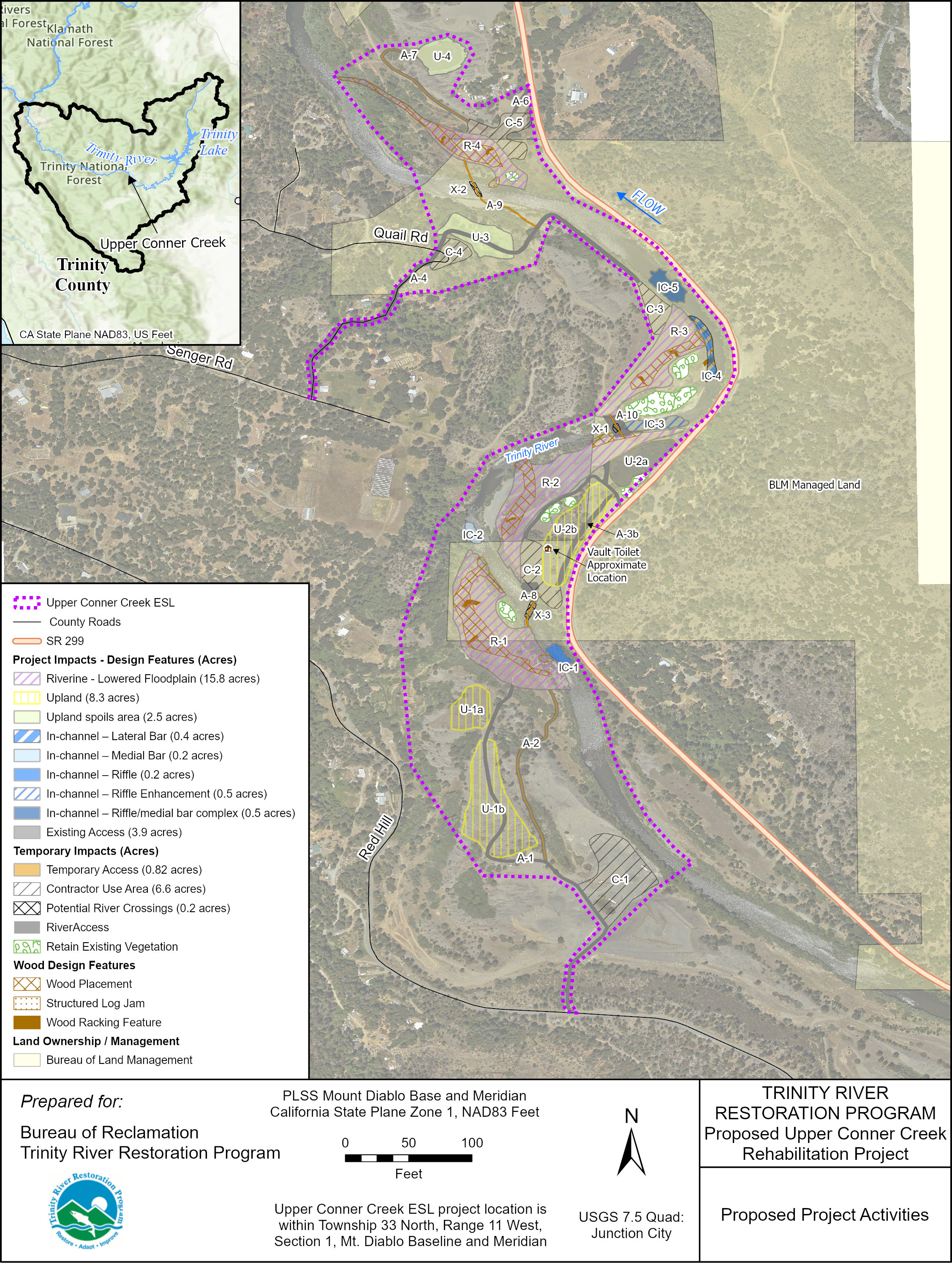
The figure below shows the proposed Upper Conner Creek project activity areas.
Upper Conner Creek Project Goals and Objectives
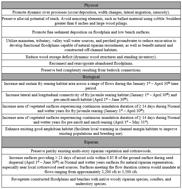
Upper Conner Creek design objectives were separated into three categories: physical, biological, and riparian objectives. In some cases, Upper Conner Creek design objectives were specific to Upper Conner Creek, while others were generic to the entire Lower Valley Design Suite, which also includes Deep Gulch and Sheridan Creek (Yurok Tribal Fisheries Program et al. 2015 2).
2 Yurok Tribal Fisheries Program, Hoopa Valley Tribal Fisheries Department, Bureau of Reclamation, U.S. Fish and Wildlife Service, NOAA Fisheries, and C. R. Agency. 2015. Lower Valley Existing Conditions Report. Prepared for the Trinity River Restoration Program, Weaverville, CA.
Possible Local Disturbances
- Highway-legal haul trucks would make deliveries of equipment, large wood, plants, and other needed materials during work hours using existing roads. This may cause road delays.
- Nearby residents may experience noise commensurate with the use of haul trucks and heavy construction equipment, such as bulldozers and excavators.