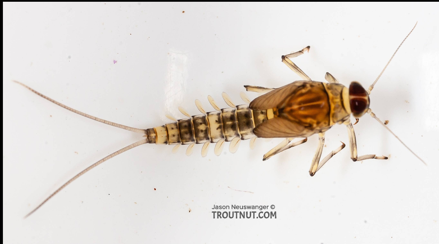
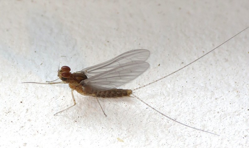
Mayflies from the family Baetidae are this month’s ‘bug of the month’. Commonly known as blue winged olives by fly fishermen, Baetid mayflies are small (<10mm) and can be extremely prolific. In addition, they grow rapidly and can have multiple generations within a year (known as multivoltine). This means that you can see adult Baetid mayflies during most of the year although they are especially apparent during the winter in early spring when few other bugs are hatching.
Photo Credit: TroutNut.com
Baetid mayflies are exceptionally adept at colonizing new habitat. They are extremely good swimmers (for a bug) and are known for undertaking what is known as behavioral drift. Behavioral drift is a strategy where macroinvertebrates enter the flow of the river voluntarily to seek out new habitat. Short life cycles, excellent swimming ability, and the propensity to undertake behavioral drift allow them to settle new habitat like when high flows inundate floodplains.
They are often the first to colonize a new area due to their swimming skills and their preference for shallow, slow water. These newly formed areas grow algae very well which is the primary food source for Baetid mayflies. They can often exploit newly formed habitat within a few weeks and live their entire life cycle within 12 weeks before other bugs get a chance to settle in an area. Seasonal inundation of floodplains are extremely important to Baetid mayflies success. Juvenile salmon have evolved to depend on the seasonal inundation of floodplains because of the presence of Baetid mayflies, which they eat for food.
Chris Laskodi, M.S., Fish Ecologist – Yurok Tribal Fisheries Department
Chris serves as the fish biologist/ecologist for the Trinity River Restoration Program in the program’s Science branch. Chris has worked on the Trinity River since 2015, previously serving as a fish biologist for the Yurok Tribe and a fisheries technician for the US Fish & Wildlife Service. Chris holds a B.S. in Wildlife, Fish and Conservation Biology from the University of California, Davis and a M.S. in Aquaculture/Fisheries from the University of Arkansas at Pine Bluff. In his free time, Chris enjoys taking friends and family fishing on one of the many watercraft available to him.
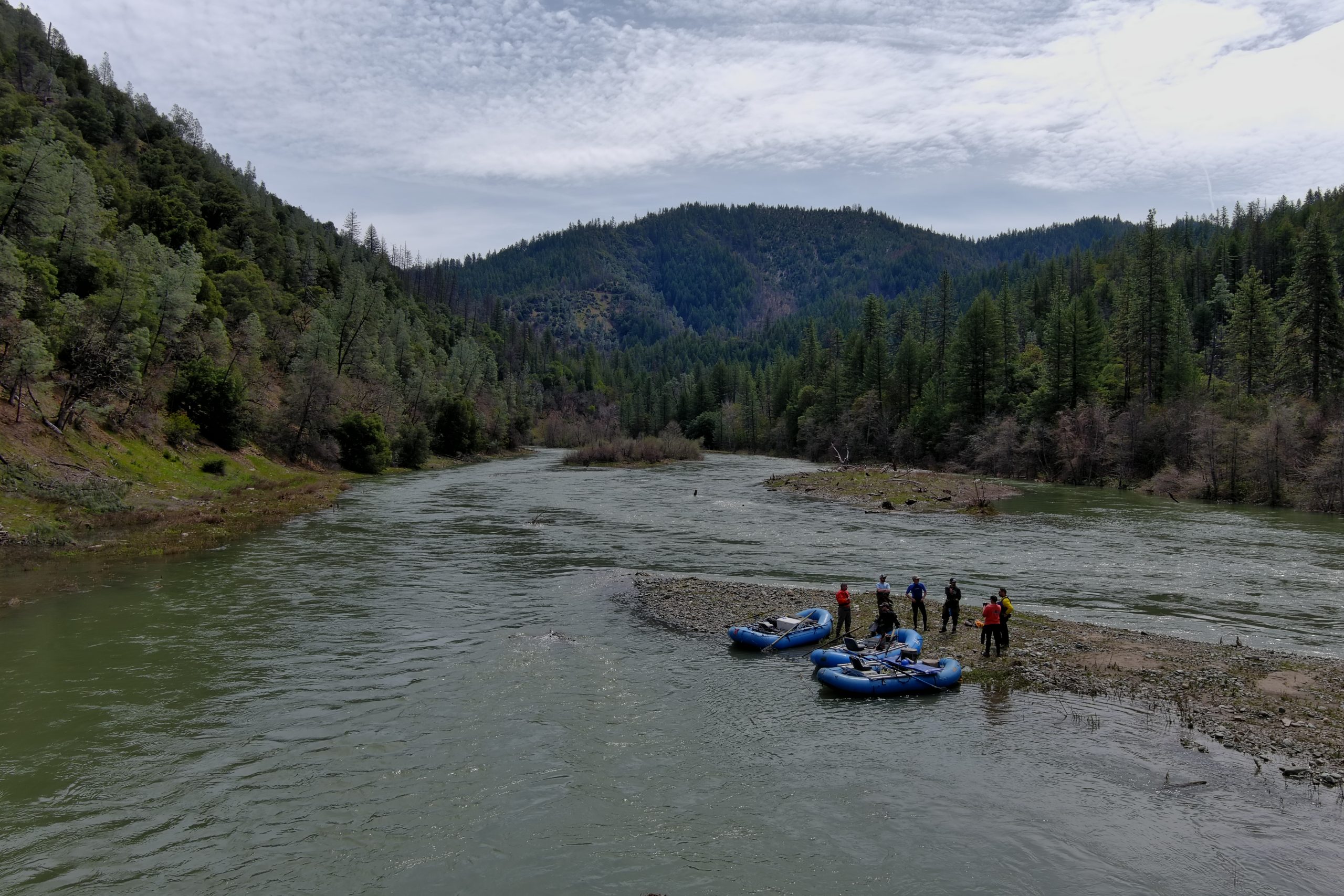
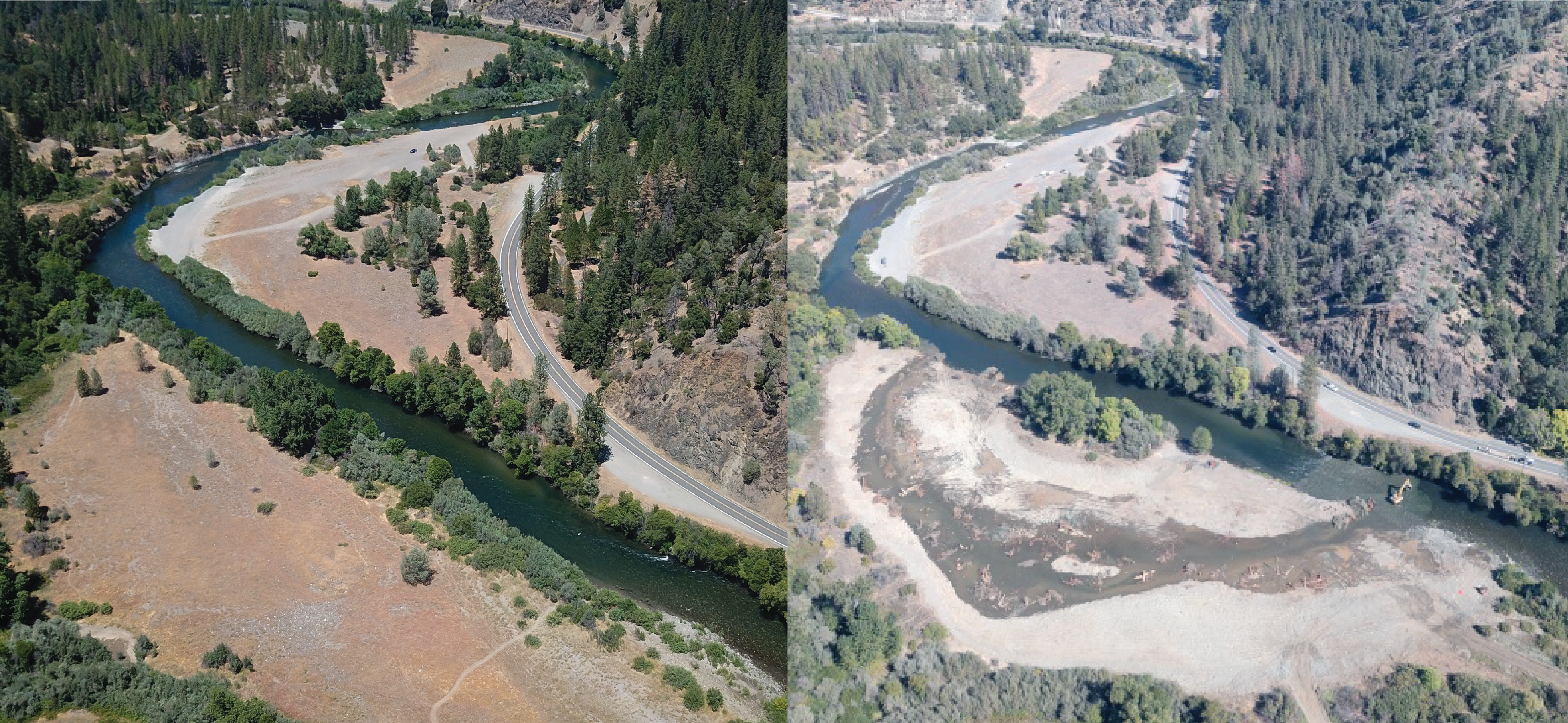
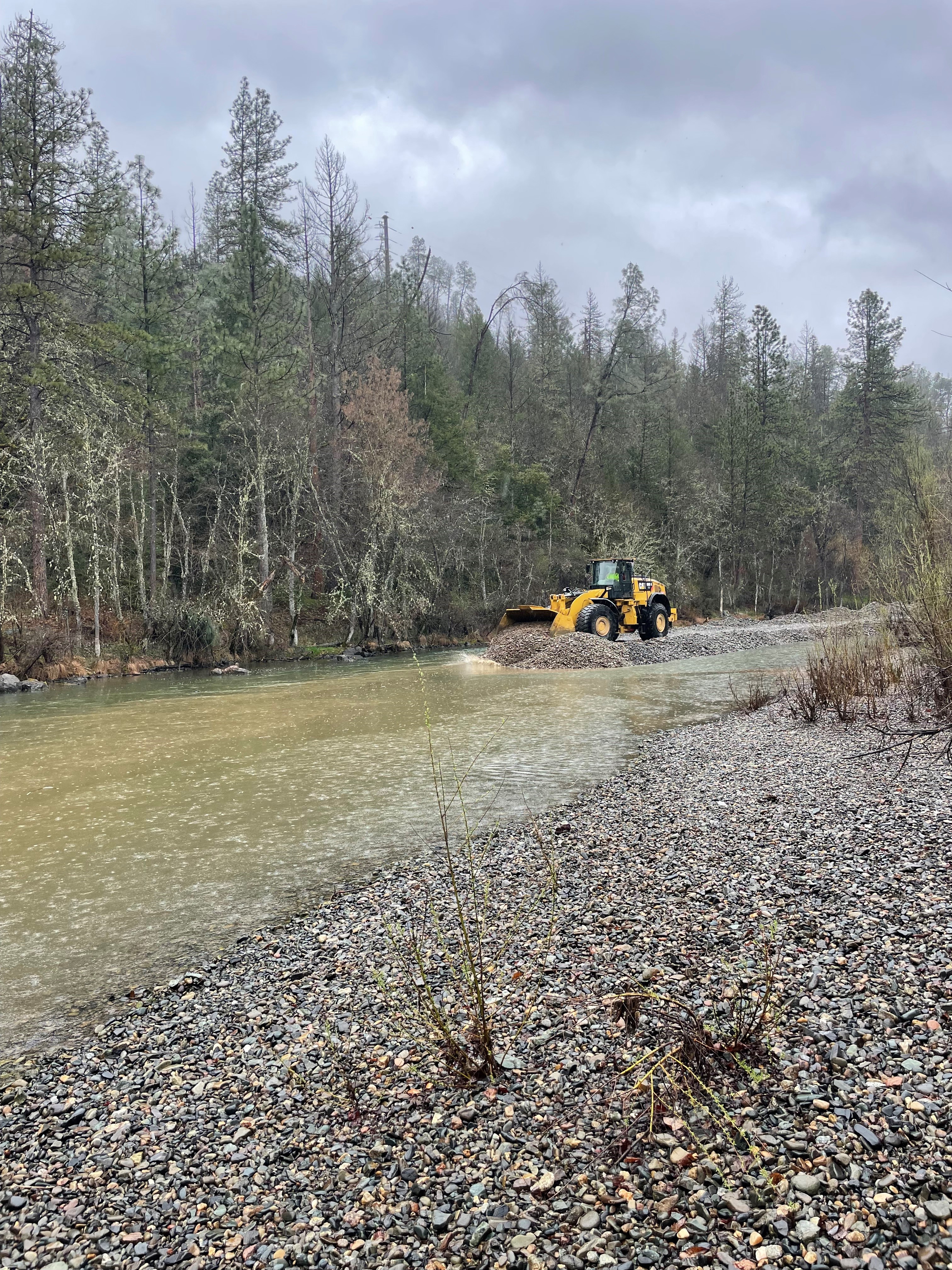
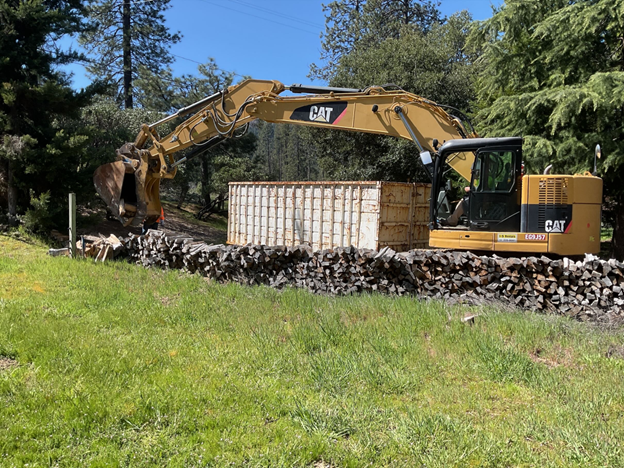
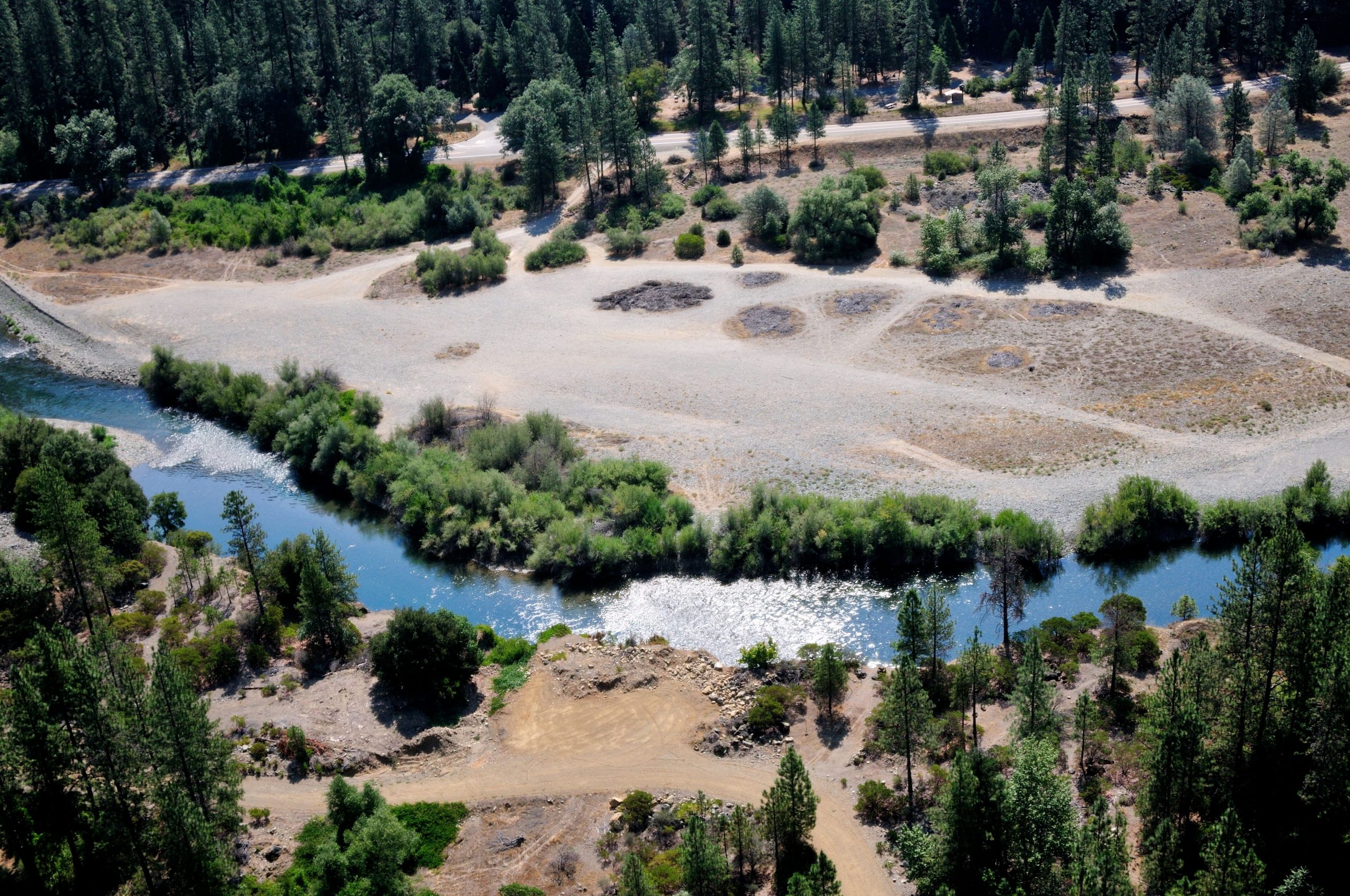
Civil construction of the Upper Conner Creek project has wrapped for 2024. Despite the late start, crews from the Yurok Tribe Construction Corporation (YTCC), The Yurok Tribe Fisheries Dept and Hoopa Roads Dept completed the first phase of construction in just under two months. Working exclusively on river left at river mile 78.3 in Junction City, the civil construction crews focused on lowering the 5.7 acre floodplain R1 and creating riffle IC-1.
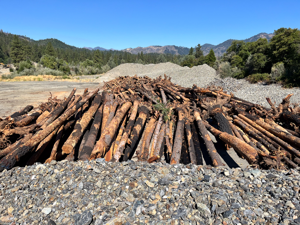
Before construction, the R1 floodplain was a largely star thistle strewn meadow, which did not fully inundate until flows reached 11,000 cubic feet per second. The Hoopa Valley Tribe’s design team envisioned a lowered surface which targeted many inundation thresholds ranging from 500 to 3500 cubic feet per second. In three weeks time, employing excavators, bulldozers, articulating trucks and front end loaders crews excavated 65,000 cubic yards of earth from the non-functional floodplain to a spoils site further inland. The civil construction team added 300 plus pieces of large wood throughout the floodplain which enables the creation of habitat with a floodplain full of hydraulic diversity.
Stockpiles of large wood which were moved and placed in the newly lowered floodplain area to encourage slow waters and habitat creation.
Constructed of fish rock (5/8-5inches) and oversized sediment (5-12 inches) a riffle at the mouth of the new side channel was enhanced. The feature’s primary function is to add roughness to the river and raise the water surface elevation of the upstream waters to encourage wetting of the newly lowered floodplain on river left. In compliance with the projects permits, the civil construction team monitored water quality during this period of turbidity generation.
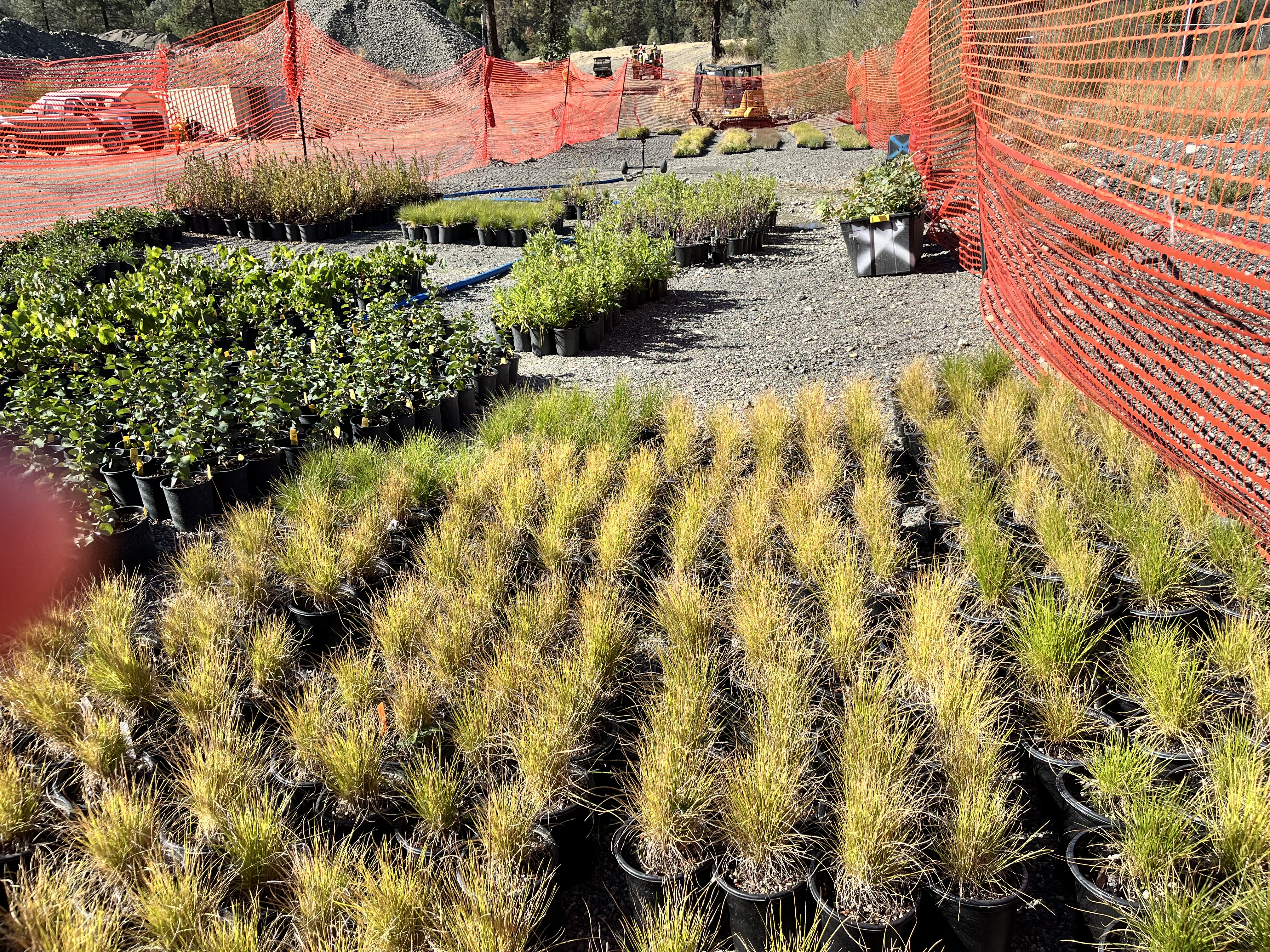
As the big yellow trucks demobilize, the revegetation crews start their work. In a temporary nursery onsite an assortment of native grasses, shrubs and trees sit soaking up sun and water while they wait for their turn to be planted. Aiming to wrap up efforts by December, the Hoopa Valley Tribal Fisheries revegetation team’s goal is to have the nursery stock entirely planted in the new floodplain and the spoils area stabilized with native grasses and straw.
As phase one nears completion, the TRRP’s Implementation Branch prepares for phase two. Just downstream, additional floodplains, riffles and improved river access spaces are all on the slate for construction in 2025. The prospect of building new recreational facilities alongside restored riverine habitat is work that we are proud to be part of!
Aerial image of the project pre-rehabilitation. [Elliot Sarnacki]
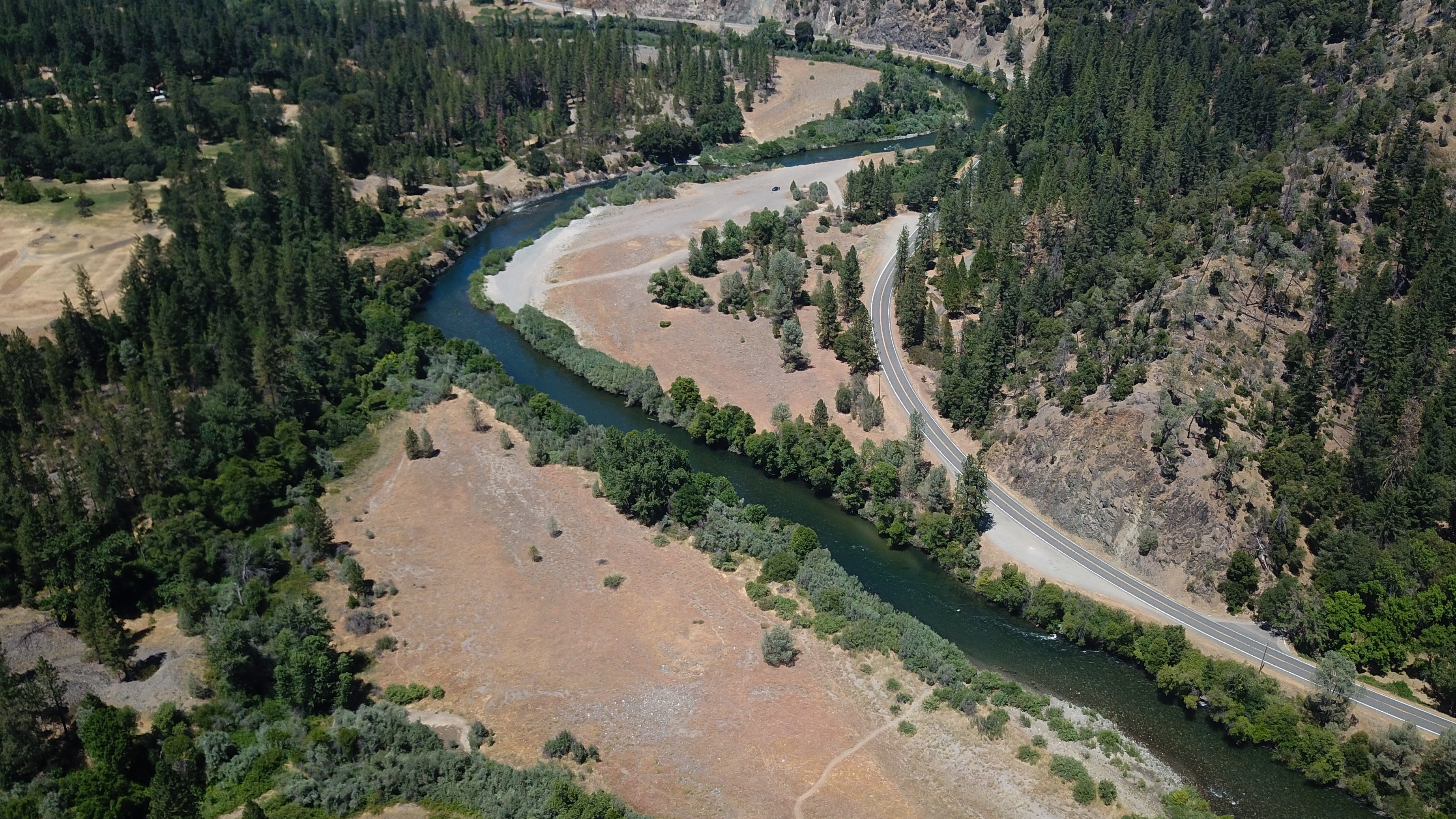
The Upper Conner Creek Rehabilitation Project is set to mobilize Phase 1 construction early next week. The site is located approximately one river mile downstream from the Dutch Creek Bridge in Junction City. After mobilization, phase 1 rehab will focus primarily on the upstream portion of the area and consists of lowering the riparian floodplain, adding riffle enhancements, placing large wood to slow water and create habitat and planting of riparian vegetation. Crews began mobilizing equipment and staging areas Monday.
The largest feature of this portion is the R1 floodplain. This 5.7 acre broadly lowered surface and pilot channel on river left targets inundation at levels from 500 to 3,500 cfs. Given that this reach of the Trinity’s average winter flow is 771 cfs, this feature should remain wetted for much of the fall winter and spring, providing low velocity salmonid refugia and opportunity for riparian recruitment.
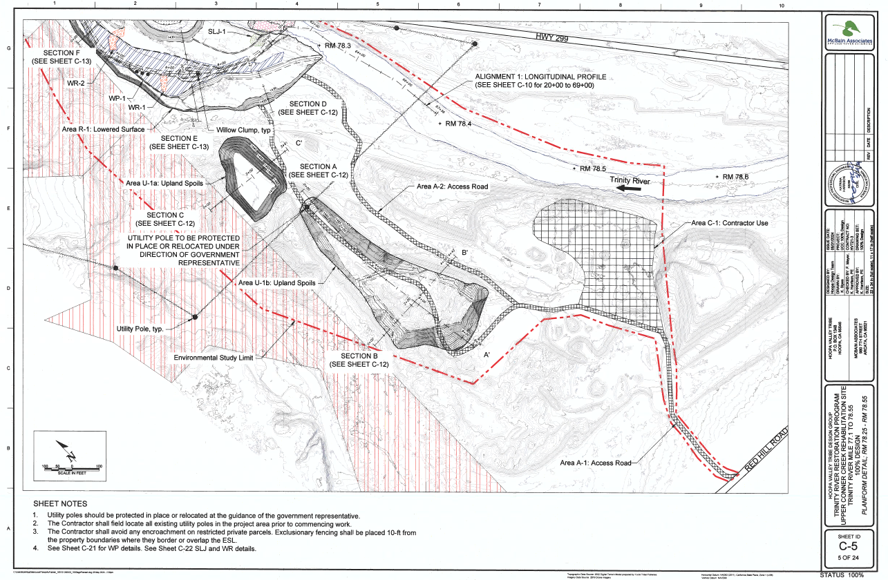
A detailed design of the Phase 1 rehabilitation at Upper Conner Creek provided by the Hoopa Valley Tribe and McBain and Associates.
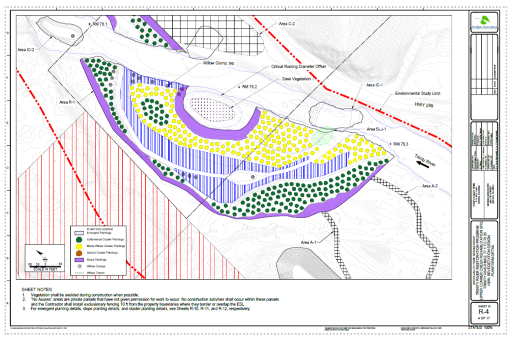
Supporting this floodplain/pilot channel feature, phase 1 will also see the construction of a riffle (IC-1 ) and the structured log jam (SLJ-1). The riffle (IC-1) is a 160ft long riffle that will raise the water surface elevation to encourage flows onto the new floodplain feature and has the added benefit of providing habitat for benthic macroinvertebrates, which are an important food source for salmonids. In between the main stem Trinity and the new pilot channel is a placed log jam (SLJ-1) which primary purpose is to provide temporary protection to the pilot channel, until riparian vegetation has an opportunity to establish. It is expected that this feature will eventually succumb to the forces of the river, but will provide low velocity salmonid refugia along the channel margins until then. Once revegetation commences this fall, the construction area will receive a compliment of cottonwoods, mixed willows, and a variety of sedges and rushes. The revegetation effort improves the aquatic habitat, helps prevent less desirable plants from taking hold, and generally speeds the healing of the river.
Revegetation design map of the Phase 1 construction area provided by the Hoopa Valley Tribe and McBain and Associates.
Junction City residents should expect to see increased traffic and activity along Red Hill Rd in the vicinity of the Smith Pit. Hours of operation on site are from 7am to 7pm, Monday thru Friday (with an allowance for Saturday if deemed necessary). Civil construction and revegetation of phase 1 should be completed by years end.
If you’d like to read more about the Upper Conner Creek Rehabilitation Project, please click here.
Large wood placement at Indian Creek a tributary to the Trinity River. [Kiana Abel, TRRP]
The Program has completed the final environmental assessment for the Sediment and Wood Augmentation Along the Trinity River Restoration Reach. It can be located by following this link: U.S. bureau of Reclamation Trinity River… 2024. – at the TRRP DataPort. The project is needed to enhance existing salmonid habitat and provide spawning and rearing habitat in the Trinity River below Lewiston Dam. This will be done by adding suitable-sized sediment and wood through manual augmentation.
Sediment management at the SVEN Olbretson rehabilitation site in the winter of 2024.
The project allows for wood and sediment placement to occur at four new augmentation sites (Dark Gulch, Trinity House Gulch, Steel Bridge, and Vitzthum Gulch) along with the five existing sites (Trinity River Hatchery, Weir Hole/Sven Olbertson, Cableway, Sawmill, and Lowden Ranch). Augmentation below the ordinary high-water mark but above the wetted channel may take place all year. High flow sediment augmentation (also known as injection) will generally take place between April and May when and where it is safe to do so without disrupting juvenile coho salmon. Sediment and wood may be placed directly into the river during the in-channel work period of July 15 to September 15 (or later in coordination with the National Marine Fisheries Service (NMFS) and with best management practices (BMPs) in place).
Each year, at each site, we are allowed to augment up to 8,000 cubic yards of sediment varying in diameter from 0.04 inches to 14 inches. We may also augment up to 700 pieces of wood varying in size from slash to whole trees at a single site per year. Generally, we will augment about 500 to 2,000 cubic yards of 0.375 inch to 5 inch in diameter sediment at a single site per year. The Physical Work Group creates an Augmentation Plan every year, recommending sites for augmentation and quantities of sediment and wood. It is unlikely the Program will augment at more than a few sites per year.
The June Quarterly meeting of the Trinity Management Council was held in Weitchpec, Ca. located near the confluence of the Trinity River and the Klamath River. The meeting was hosted by the Yurok Tribe and took place Wednesday, June 5 and Thursday, June 6. During the first day members received presentations from the acting Trinity River Restoration Program Executive Director, James Lee regarding program updates. Topics in the Executive Directors Report covered major activities since the March TMC meeting as well as organizational updates, budget updates, Implementation Branch updates, Public Outreach updates and Science Branch updates. The ED Report can be downloaded by clicking here.
Additionally the council received updates from various membership staff regarding Central Valley Project operations (Elizabeth Hadley, Reclamation), Trinity River Division Reconsultation (Kristen Hiatt, Reclamation), Fish workgroup synthesis report recommendations (Kyle De Juilio, Yurok Tribe) and TRRP channel rehabilitation site status and schedule (Oliver Rogers, TRRP). There were two informational presentations given to the council, the first a presentation from Whiskeytown National Park Service staff regarding the policy around keeping Whiskeytown Reservoir full as well as a presentation on the Remote Site Incubator (RSI) program (download the presentation) implemented by the Yurok Tribe on Grass Valley Creek in spring of 2024 by Zac Reinstein.
On day 2 In addition to a presentation from Hoopa Valley Fisheries Department Director, Mike Orcutt on chinook management post-Klamath dam removal in the second day of meetings the council received 3 presentations focused on program updates and 2 presentations regarding updates to TMC procedure. The first presentation was given by the TRRP Science Coordinator, Eric Peterson who updated the council regarding fiscal year 2025 science proposal recommendations. Second, James Lee, acting Executive Director presented the proposed budget for fiscal year 2025 for council approval. The council voted unanimously to adopt the FY25 budget proposal with one amendment. The amendment reads as the following, “Mike Orcutt made a motion to follow the IDT’s recommendation to fund the additional three proposed projects up to $610,000 subject to IDT team review and contingent on their concurrence. The projects proposed include the Restoration Vegetation Diversity (TRRP-2025-1), Benthic Macroinvertebrates (TRRP-2025-2) and Initial Steps to Foodscape Model (TRRP-2025-3).”
In the afternoon, the TMC discussed amending the bylaws to more clearly define procedure in calling for executive session during management meetings. The TMC voted unanimously to amend this section to read as the following, “All regularly scheduled and special meetings of the TMC shall be open to the public except executive sessions. Executive sessions shall be comprised of one representative per TMC entity and invitees. Executive sessions shall be limited to issues related to contracts, personnel, legal matters, or other sensitive matters as determined by the TMC. The request for a specific executive session (including invitees) will be clearly proposed via a motion and voted to proceed by the TMC in accordance with Sections 603, 604, and 605.“TMC bylaws (Section 600, Bullet D)
The final topic of the quarterly meeting was a discussion titled, Winter Flow Variability Planning and was brought by TMC member Radley Ott, who serves in the seat for California Natural Resources Agency. The discussion centered around the desire from technical groups and the public, who have expressed the need for advanced planning regarding water management. These groups were looking to the TMC for guidance on how Water Year ’25 would be managed with the knowledge that the management council was not able to pass a flow recommendation to the Department of the Interior in Water Year ’24. The council decided on creating a timeline for proposals that would include both limitations as well as implementation. The motion, that passed with 1 vote against and 7 votes in favor, reads as follows, “Any recommendations or conditions for WY 2025 flows between 01 Oct and 15 April are to be submitted to the Flow Workgroup by 19 July and any specific hydrographs are to be submitted to the Flow Workgroup by 9 August.”
While it has not been a focus of the TRRP for many years, infrastructure improvement was one of the foundational tasks that was laid out in the 2000 Trinity River Mainstem Fishery Restoration Record of Decision. Years of low, predictable flows had led riparian property owners to develop very close to the river’s edge. In order to implement restoration releases, the TRRP has worked with willing property owners to upgrade or remove infrastructure that could be damaged by restoration flow releases as guided by the “maximum fisheries flow” boundary.
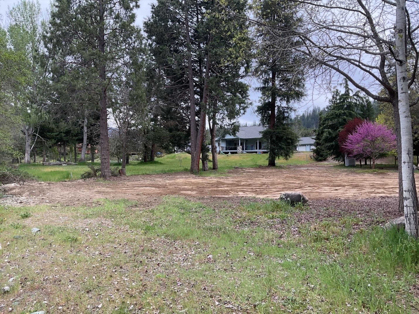
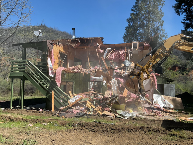
A photo of the cleared River Acres parcel, post demolition, April 2024.
The maximum fisheries flow is an 11,000 cubic feet per second release from Lewiston Dam (the highest the program can target for restoration objectives) that coincides with a major spring storm event. In the program’s first decade, there was a big push to address permitted infrastructure to clear the floodplain for fisheries releases; we moved roads, replaced several bridges, upgraded dozens of septic and water intake systems, and relocated a house in Douglas City. Another house (391 River Acres Rd in Junction City) was identified as being inside of the maximum fisheries flow boundary, but the owners were not interested in improving or selling their home at that time.
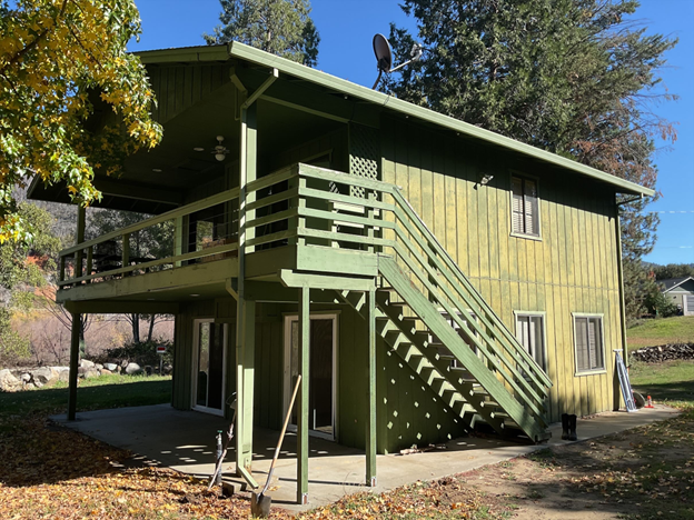
The River Acres House prior to removal, winter 2024.
The circumstances changed in the late 2010’s when the house sold to a new owner who used it as a fishing cabin and was very interested in finding a mutual solution that would benefit Trinity River fisheries. Together with engineers and architects the landowner and TRRP explored moving the house, building a levee, and elevating the living area with a flow-through bottom story. In the end, none of those solutions proved feasible due to flood concerns with adjoining properties and other constraints. The situation led the homeowner to decide to sell the house to the Bureau of Reclamation, who acquired the property in 2023.
In March of 2024, Cal Inc., a certified small business located in Vacaville, California was awarded the contract to demolish the 391 River Acres structures. Cal, Inc., specializes in general construction, abatement and remediation services, and environmental and safety training, and it took their professional staff only a few weeks to gather intel, test for lead and asbestos, and mobilize machinery, crew and subcontractors to begin the demolition.
Over the course of the week of April 8 the domestic water well and septic system was decommissioned, the structures and concrete pads were reduced to splinters and rubble, and an entire fence line of firewood was donated to a local charity.
The first crunch of an excavator bucket flattening an outbuilding occurred Monday morning and by Friday a final few sweeps of a hard-tine rack flattening the vehicle tracks left from construction. The materials left were loaded into what amounted to 12 dumpsters and was hauled-off for proper disposal.
Over the course of the week many of the neighbors wandered over and reminisced about those who had called the River Acres house home (or home away from home) over the years. They were understandably sad about losing a piece of River Acres history but were excited about the open space for their dogs and grandchildren to run and play in. We appreciate their tolerance of the noise, construction and extra visits these past few months. The project will be considered complete once the bare areas have been mulched and seeded, likely to be fully complete by the first of May.
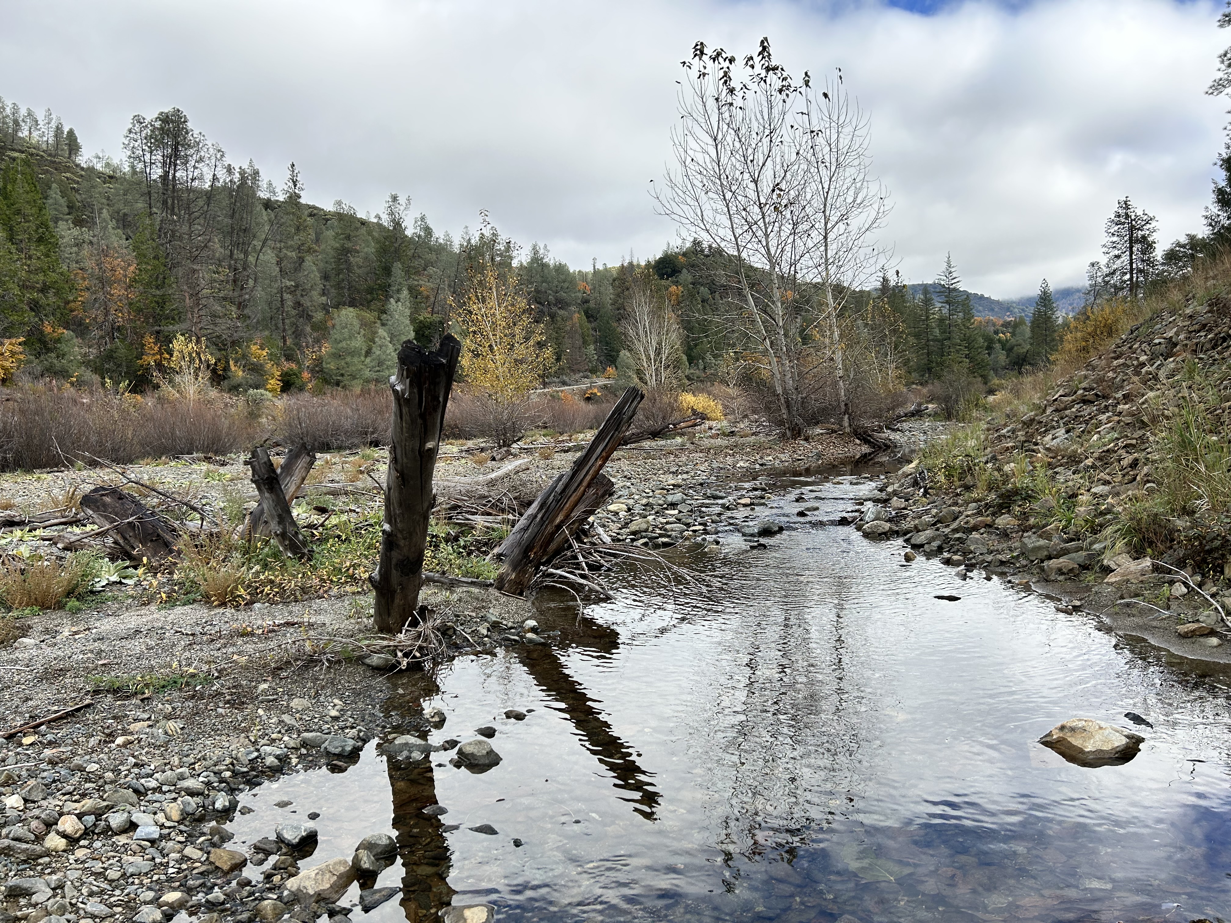
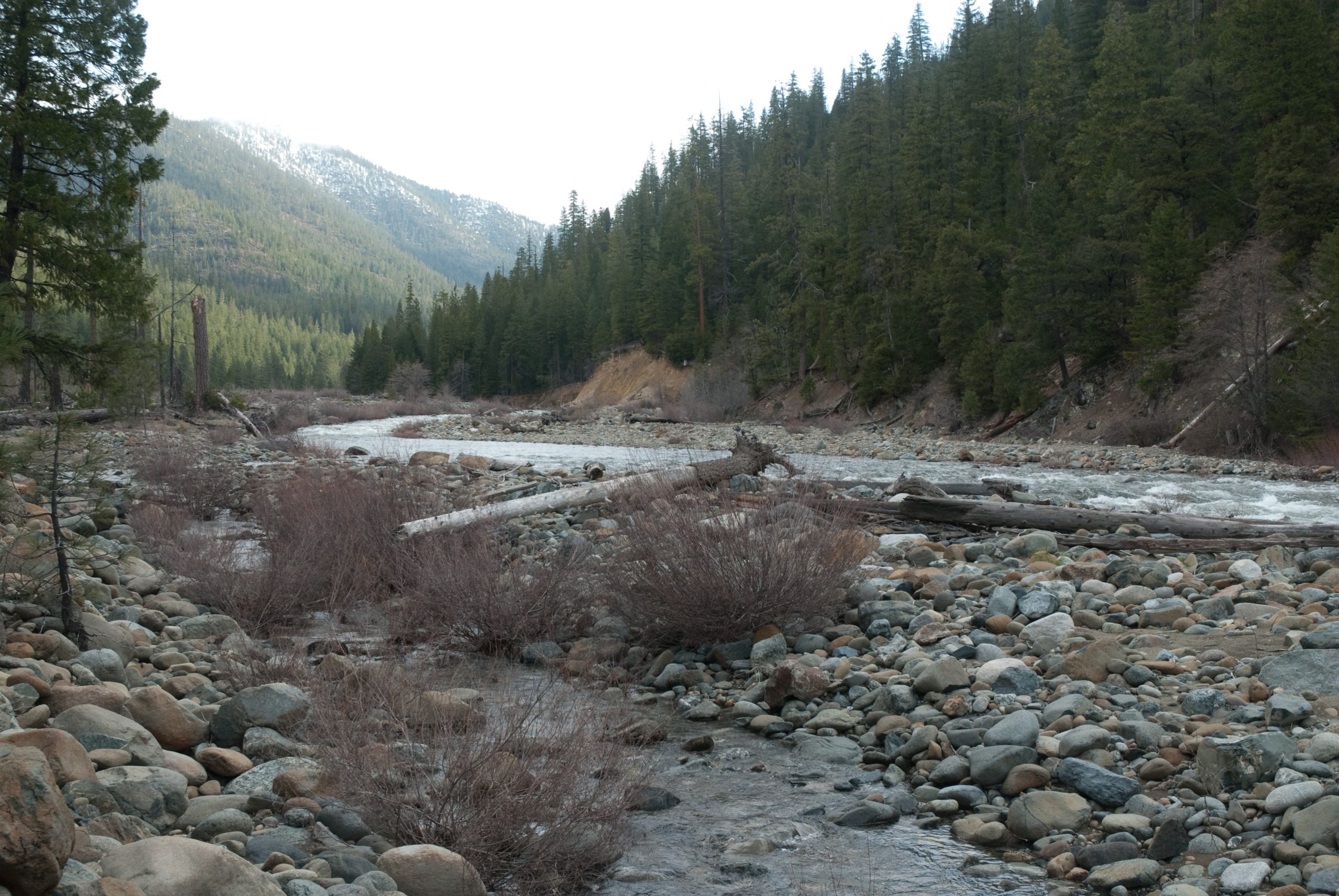
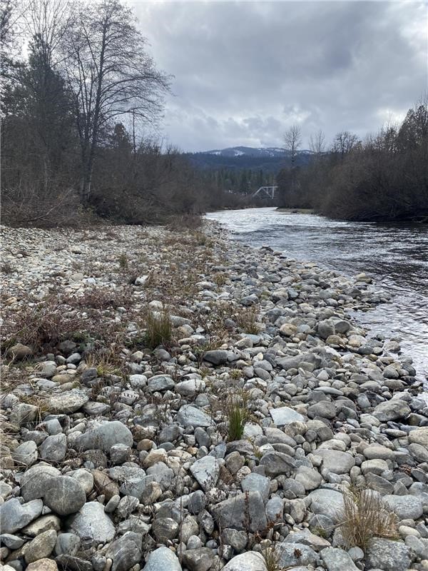
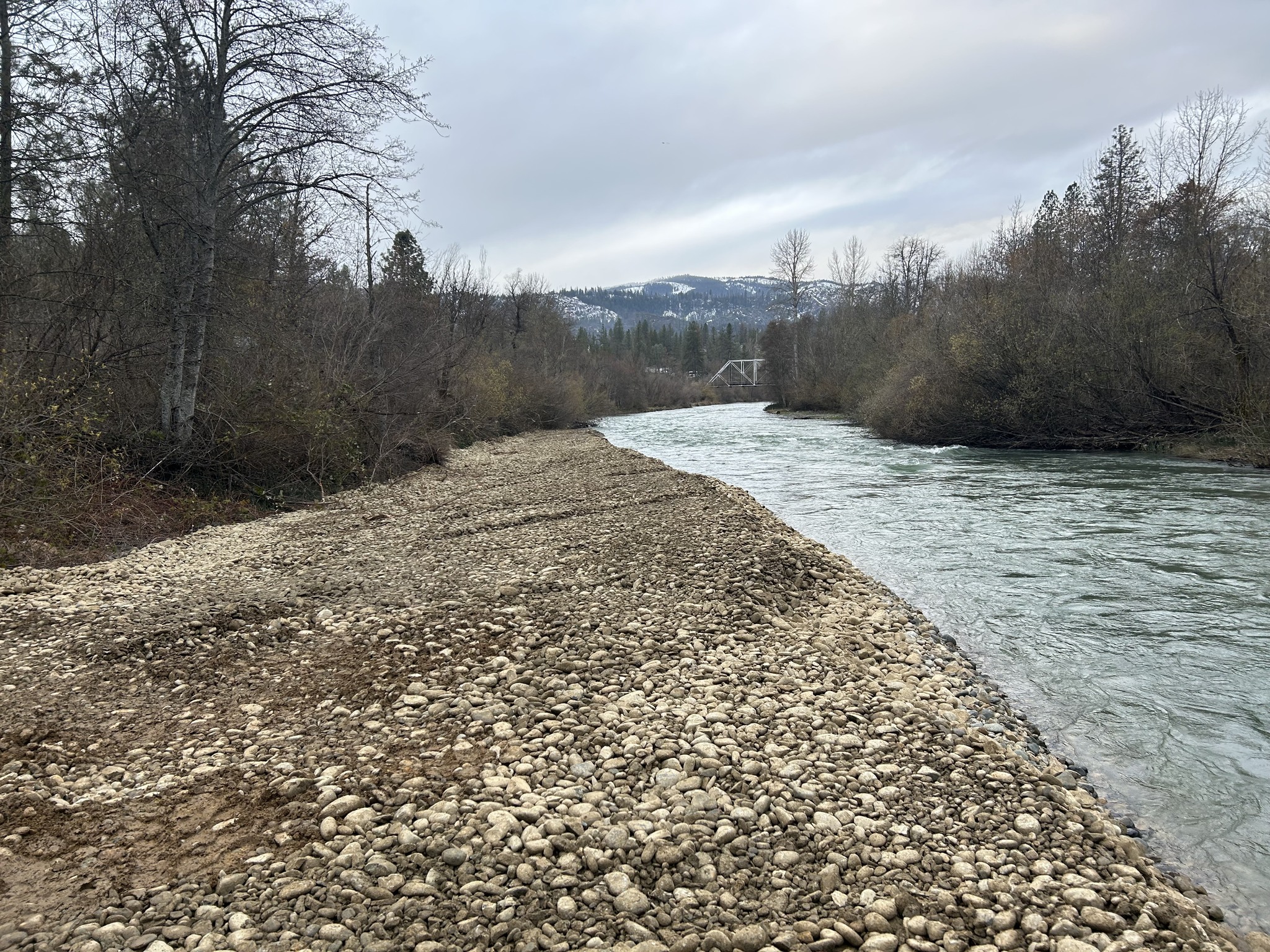
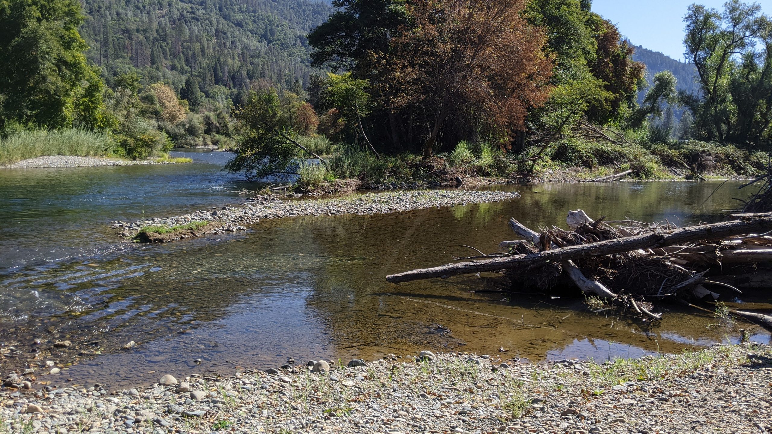
When you go down to the river, it’s hard to ignore the assortment of sediment on the bed and banks – from sand and silt, to gravel, to larger cobbles, to the largest of boulders. Seeing rocks that contrast so strongly with the rough, jagged ones in the surrounding hills might beg the question – how did these get here, where did they come from, and how long ago did they arrive?
Photo: Riparian area along the Trinity River above Trinity Reservoir showing an assortment of sediment, vegetation and large wood. [TRRP]
If a rock is rounded, more likely than not [1] it was transported by the river in a series of floods, originated from higher up in the watershed. Depending on the size these rocks may have arrived recently – perhaps as recently as the last flood. Large, rounded boulders that appear to be too large to have been rolled down the river on their own may have been in place since the last natural 100-year or 500-year flood and may remain there forever, or at least as long as Trinity and Lewiston dams are in place.
[1]Gold miners washed much sediment into Trinity River valleys from ancient riverbeds created from tectonic lifting that are presently high up on mountain slopes.
A river’s function
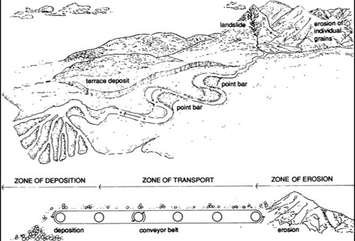
Besides the ecological benefits that rivers provide us, they have two pivotal functions in nature – to move water and to move sediment from the mountains to the ocean (the process is illustrated below). As both water and sediment flow downstream, they interact with each other to create a mosaic of pools, riffles, runs, islands, meanders, bars, and all of the other physical features that draw people, plants, and animals to a river.
“Conveyor Belt” conceptual model of sediment transport. Rivers move water and sediment from the mountains to the sea.
The Trinity Watershed is situated in a relatively young, steep, and highly erodible mountain range, and is therefore blessed with a plentiful supply of sediment. A healthy sediment supply is beneficial to fish, invertebrates, and floodplain vegetation. However, due to the placement of two dams in the Trinity River’s upper watershed an important element of restoration is giving gravel to the system below a dam since the river’s natural sediment supply is blocked. We know rivers below dams need a replenished sediment supply, however, a key question that geomorphologists continue to study is how much sediment, and what size distribution of sediment should be added? These factors are difficult to determine and are constantly being re-evaluated as part of our adaptive management program.
How we calculate amounts for placement
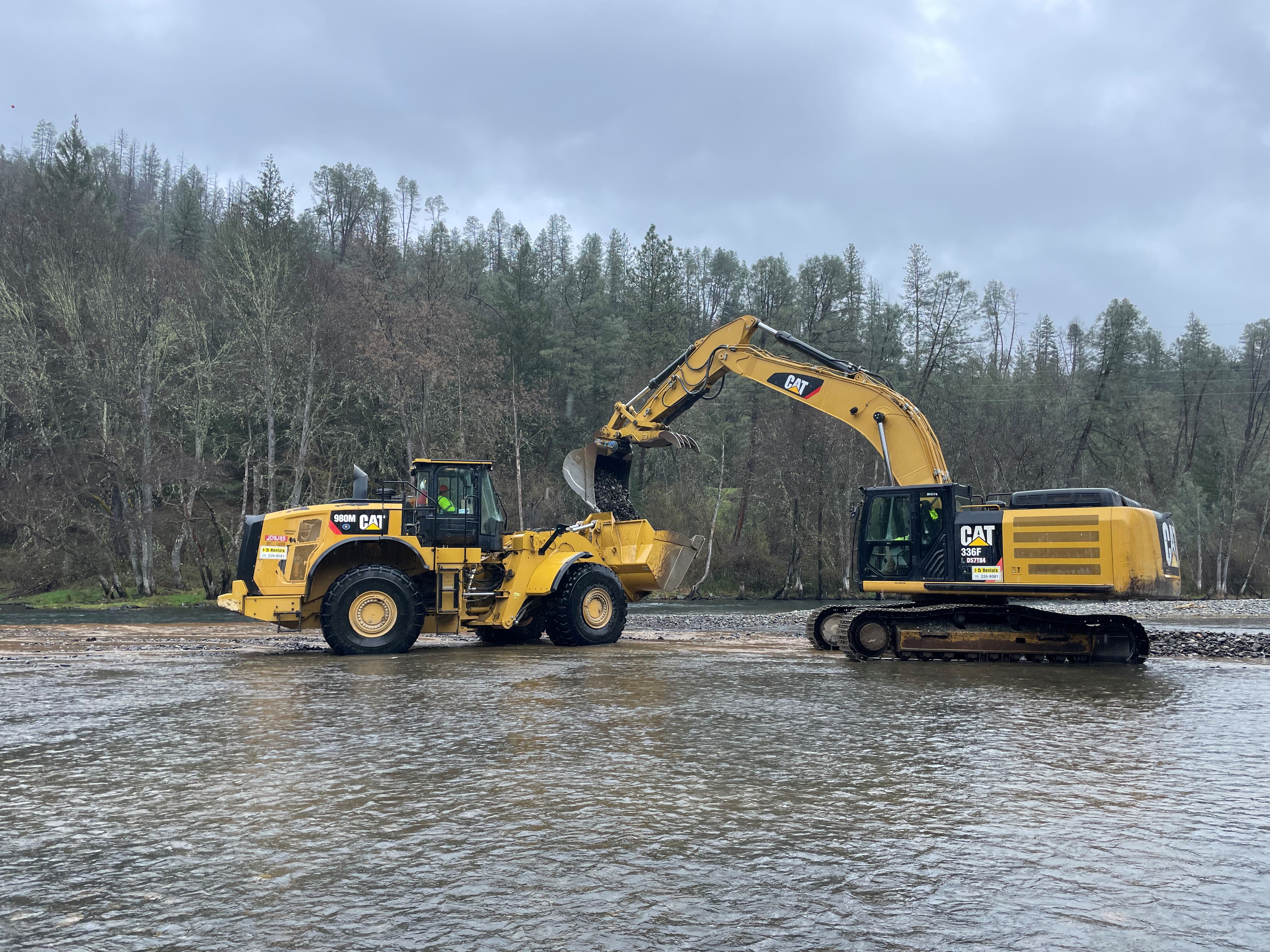
Gravel augmentations to the river are first determined using a defined sediment budget specific to the Trinity. Also, at some point below most dams, a river’s tributaries provide a sufficient supply of sediment to support the physical processes and biologic populations in the river. On the Trinity, that point is considered to be just below the junction of Indian Creek. In years past, during floods, the amount of sediment moving along the bottom of the river (called ‘bedload’) was directly measured with large strainers placed on the riverbed. Data obtained from the strainer monitoring station have indicated that minor floods may move 2,000-3,000 tons of bedload (the monitoring station that is nearest to Indian Creek is located just upstream of Douglas City campground). At this same location, larger floods may move 15,000-30,000 tons of bedload past the monitoring station. The Trinity Record of decision provided the program with a framework of how much sediment should be applied to the river below the dam with the expectation that geomorphologists study current conditions through time and then adapt management based on results found.
After many years of physically sampling bedloads, program scientists switched to a more efficient and safer technique called acoustical monitoring. This method uses underwater microphones to quantify the amount of sediment during floods by measuring the amount of noise generated by rocks rolling on the bed. The physical data collected from the past is then compared to the measured volume of noise and produces a calculated volume of sediment rolling past. Scientists then scale annual sediment augmentation projects to these measured amounts. Additionally, the riverbed is periodically surveyed below sediment augmentation sites to determine whether the effects of placements are positive or negative. If too much sediment is noted, this information is used to scale back future sediment augmentation plans. If you were to compare the original amounts of sediment proposed in the Trinity Record of Decision to what we add today, ROD volumes were 2-3 times higher!
Above Photo: a 2023 gravel augmentation site pictured prior to high flow. Right Photo: the same site pictured after the gravel was dispersed by high flow.
Size matters
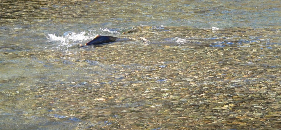
As for size, the high end of the size distribution of sediments is the grain diameter that salmon can move to construct redds, or nests in which they place their eggs for incubation. Salmon can spawn in gravels with a median diameter up to about 10% of their body length. This leads to gravel being placed in the river that was filtered through a 4-inch screen. The lower end of the size distribution of sediment for redd building is considered to be in the size range of small gravel, and so the sediment mixtures for placement in the river are also screened to remove sand and silt. If the sediment is too small, it just flushes all the way down the river during floods and doesn’t remain to provide any benefits. If the sediment is too large, it stays close to the augmentation site and causes the riverbed to become coarser there. The need for small to large gravels for placement makes considering the size distribution between these end points important. Too many small gravels make the riverbed overly mobile and easy to scour, which endangers salmon eggs incubating in the bed. However, a grain-size distribution that is skewed towards larger particles makes the riverbed too stable, so that salmon are unable to move the sediment when attempting to construct a redd. These considerations make the size class of sediment another subject of adaptive management, and over time TRRP has reduced the size of sediment that is added to the river. Studies have also pointed toward ways that coarse sediments (gravel and cobble) interact with fine sediment (sand and silt), and restoring a natural balance of these grain sizes is an objective of the sediment augmentation program at the TRRP. In the future you may hear of sediment with a more natural size distribution (e.g., “bank run material”) being used in sediment augmentation projects.
Salmon spawning in gravel in the Trinity River.
Filling deep pools
When you observe a river during typical baseflows, pools are calm while riffles are noisy, turbulent and swift. From an above water view, its natural to think that sediments would settle from these active riffles to its calmer neighboring pools. During low flow, if you look underwater, the river only has the power to move finer sediments, like sand and silt. Conversely, coarse sediment, such as gravel and cobble move only when the hydrology of the river is powerful with high flow or flooding.
When rivers flood, we see something that river scientists call a “flow reversal”. Flow reversal is when deep pools transition into a high-energy environment where flow velocity is more vigorous than on riffles. In this instance water meets the pool (and its surrounding environment, like bedrock) with force and activates sediments of different sizes within the pool. These sediments are “scoured” from the pool and placed on the riffle below it typically expanding a pool’s depth and also building the riffle below. Next time during a high flow, check out the way a pool churns and take note to notice the way water interacts with the riffle that lye underneath. During high discharges, flows on riffles are comparatively slow because the surface is not as deep. This interaction causes the water to “feel” the bed and slow due to its rough texture. These interactions cause sediment to deposit on riffles and scour from pools during high flows. The size of sediments that move are directly correlated to the amount of water flowing down the river and these events are the force behind building the riffles and pools of the Trinity River.
Dave Gaeuman, Senior Geomorphologist for the Yurok Tribe talks about the importance of variable flows and and how sediment transports from riffles to pools
TRRP sediment augmentation projects have sometimes been thought to contribute to the filling of deep pools in the river and there have been cases where pool depths have decreased in areas that the TRRP has worked to restore the river. However, TRRP studies have shown that this tends to occur where stream power decreases in the channel from lowering the elevation of adjacent floodplains and vegetation, which causes the flow to spread out instead of concentrate in the channel. In many areas of the Trinity River, lowering floodplains is necessary to reconnect them with the river during floods for the benefit of the fish, wildlife and plants that live there. This conundrum is another subject of adaptive management, and TRRP often avoids actions that would have a strong likelihood of affecting pool depths so that holding habitat for over-summering fish such as spring-run Chinook salmon remains available.
The next time you visit the Trinity River, take a close look at the sediments that you see. Depending on the time of year, you may see salmon redds constructed of gravels. You will also most likely find aquatic invertebrates and biofilm living on the gravel and cobbles surfaces. Dig into a sand and silt deposit along the channel margins and you might find juvenile lamprey wriggling around in these materials. You will certainly see how sediment forms the shape of the river. And hopefully you’ll come away with a greater appreciation of sediments that are the building blocks of the Trinity River!
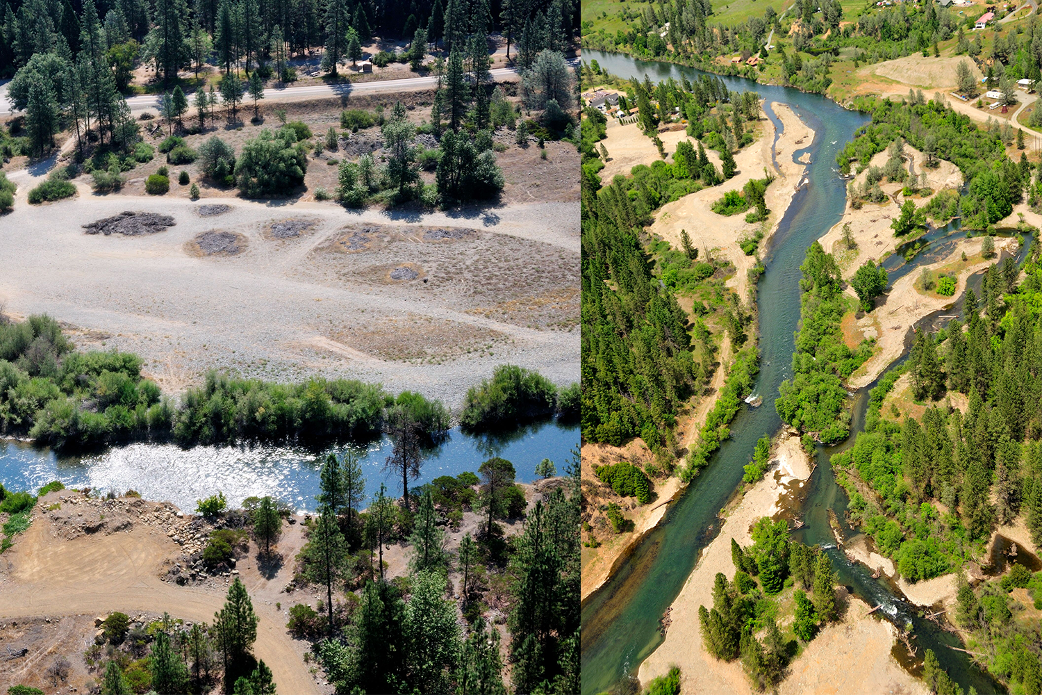
With winter fully here and the holidays behind us, the Implementation Branch is moving forward with some exciting restoration proposals. In recent past the TRRP publicly scoped two proposed channel rehabilitation projects, the Upper Conner Creek Rehabilitation Project in Junction City and the Sawmill Gravel Processing Site Project in Lewiston. A draft environmental assessment (EA) will be released in the coming weeks, and then the Implementation Branch and those involved in the project will host a public meeting to discuss the proposed designs and restoration activities. Keep an eye on our calendar or our facebook page for notification of that meeting. We hope to see you there.
Photos of the two proposed channel rehabilitation sites currently under Environmental Assessment, Upper Conner Creek (left) and Sawmill Gravel Processing Rehabilitation (right).
Proposed Upper Conner Creek rehabilitation project
The proposed Upper Conner Creek project designs were prepared by the Hoopa Valley Tribal Fisheries Department and McBain Associates. Long term assessment of past restoration work nearby and adaptive management have led program partners to determine that the lowered surfaces of these early projects were not inundating (providing low floodplain habitat) frequently enough. Improvements in floodplain connectivity to the mainstem, as well as course sediment additions and large wood features will open opportunities for the river to rework its form to provide long-term channel complexity and high-quality salmon habitat. The recreational aspect of this area is appreciated by many and was an important feature to consider for this project. Through consultation with local residents and river users, project designers have worked to maintain the Junction City Campground’s river access for boating and swimming. The proposed Upper Conner Creek Project first phase of restoration will begin in the spring of 2024.
Aerial shot of the proposed Upper Conner Creek rehabilitation site [Kenneth DeCamp]
Proposed Sawmill Gravel Processing Site Rehabilitation Project
The proposed Sawmill Gravel Processing Site Rehabilitation Project, prepared by the Yurok Tribal Fisheries Department, the California Department of Water Resources, and the California Department of Fish and Wildlife, seek to decommission a portion of a long-used sediment processing site and do so in an ecologically beneficial way. The proposed project also intends to address a floodplain breach on river right that has dewatered a side channel complex. Repairing this breach will allow adult salmon to spawn throughout the side channel as they have historically.
Sediment and Wood Augmentation Environmental Assessment
Also working its way through the environmental compliance pathway is the TRRP’s Sediment and Wood Augmentation EA. The EA seeks to establish four new augmentation sites and allows for wood placement at the five existing sites in addition to sediment augmentation to address the sediment and wood deficiency upstream of Indian Creek. The new augmentation sites are also located in the upper river near Lewiston and include Dark Gulch, Trinity House Gulch, Steel Bridge, and Vitzthum Gulch. The wood component of the analysis is an exciting addition to the EA. Wood is critical to a dynamic river system as its benefits include creating fish cover, adding hydraulic complexity, connecting the main river with important fish feeding grounds called floodplains, retaining sediment and aiding a variety of river species by creating more robust habitat. The EA wrapped up its public comment period on November 22 and the public draft is available on TRRP.net.
A rehabilitated side channel and large wood placement at the 2021 Chapman Ranch Rehabilitation site saw adult salmon building redds this past fall. [Todd Buxton, TRRP/Reclamation]
Trinity River Watershed Restoration Programmatic Environmental Assessment
Finally, the TRRP’s Trinity River Watershed Restoration Programmatic Environmental Assessment (PEA) is on track to be completed in 2024. The PEA focuses on improving the quality and quantity of accessible cold-water aquatic habitat throughout the lands which flow to the Trinity River. A goal of the PEA is to encourage more stream and riparian habitat restoration projects by providing National Environmental Policy Act (NEPA) coverage to organizations who propose areas in need of restoration.
Since the foundational 1999 Trinity River Flow Evaluation Report, decades of scientific research have poured into improving outcomes for Salmonids, both from within the Trinity River Basin and from rivers researched across the world. The cumulation of data has made scientists within the Program increasingly aware that shifting how the Program uses restoration flow allocation has the potential to lead to stronger and more resilient juvenile salmonids.
Survey crews monitoring the interaction between high flows and recently restored floodplain on the Trinity River in April of 2023.
Restoration releases continuing through late spring and into the summer keep water colder than optimal for juvenile salmon growth. With size of outmigrating salmon strongly tied to their survival in the ocean, the correlating smaller sized salmon has led scientists to question if a change in management actions would benefit juvenile salmon. Further, Program scientists have figured out that greater than 60% of young chinook salmon have already left the restoration reach by the time spring restoration releases start to interact with restored habitat created by the Program over the last 18 years. River restorationists believe that if floodplains and side channels can get wet when more juvenile salmon are in the upper river to use them, then they can take advantage of all the extra food that those habitats create and if the water meets a range of ideal temperatures for these cold-blooded creatures, they will grow faster.
A partial implementation of an initial proposal to shift a portion of the annual restoration flow allocation earlier in the year occurred in the winter/spring of Water Year 2023 (partial because only elevated baseflows were implemented. The synchronized pulse flow component was not implemented); in September 2023, Program scientists proposed the same action for Water Year 2024 to the Trinity Management Council indicating to the Council that the proposal was the best available science in improving results for salmonids. Unfortunately, the TMC requires near unanimous votes to approve actions and failed to approve that proposal, with six votes in favor and two opposed. However, all was not lost. A group including Trinity County brought in a retired USFWS biologist to review the proposal and findings from the Water Year 2023 and offered to work with program scientists to craft a proposal that was perceived to be less problematic for late winter/early spring river-based recreation and its associated economic benefits. Parties worked together busily behind the scenes, and the revised winter flow proposal will be presented to the TMC at a special meeting on Jan. 18. If approved, modestly increased winter base flows would begin in February.

![Aerial image of the proposed Sawmill Gravel Processing site. [Ken DeCamp]](https://www.trrp.net/wordterrain/wp-content/uploads/2023/11/Sawmill-Ken-Decamp-2010-680x1024.jpg)
![Restoring the lands that surround the Trinity River is an important part of system restoration. [Trinity County Resource Conservation District]](https://www.trrp.net/wordterrain/wp-content/uploads/2023/11/Picture2-1024x552.png)